The 2021 Zimmatic Trailblazer Sustainable Irrigation Awards is now on and entries are open!
The Awards celebrate excellence and recognises New Zealand farmers demonstrating leadership in water management and environmental stewardship. The judges are looking for steps taken to ensure sustainable water use on farm and an obvious passion for protecting one of our most precious natural resources. They had an overwhelming response from farmers last year in terms of entry numbers. This year, they would like to invite you to lend your support and help us build on this success.
Please help us spread the word through your own networks and encourage farmers in your area to enter themselves or nominate someone else that they think is deserving. You may even have friends or neighbours who are worthy of being nominated. If so, please put their name forward! This year’s competition is open to New Zealand farmers who irrigate more than 25ha.
The online entry and nomination process is simple, just visit the Awards website irrigationtrailblazer.com and click the red links on the home page to access the appropriate form. You can find out what impressed our judges last year in our two part leading submission summary; click here for Part 1 and Part 2. We hope this provides you with some insight into why the leading entrants from the 2020 awards caught the judging panels eye!
Servicing your soil moisture probe sites gives your telemetry the best chance at performing well – and is a service we offer! As seen below, these are common problems our technicians come across in the field; pugging, chewed cables, and blocked rain gauges. Whether you use your data to guide your decisions on farm or you simply rely on your data for auditing and compliance purposes, these issues won’t be helping your case.
Our soil moisture site service includes a rain gauge calibration, because over time being exposed to the elements, things can change. If you feel that your rain gauge data is out of line, we are more than happy to calibrate it for you. We also check over the quality of data your probe is creating to ensure that it is settled and as accurate as possible. Whilst on site, an assessment of the surroundings is taken to see whether moving the probe would be beneficial, that solar panels are facing north, no pugging has occurred, and that rain gauges aren’t blocked. An annual soil moisture report is then crafted up by one of the technicians for you to keep and reflect over for the coming months. Any further advice required will be also given.
An Electro-magnetic (EM) Survey is one of the key layers required on the precision farming journey. Precise location and understanding of soil types is a key piece of information in driving decisions around water use and nutrient placement. Not only can an EM Survey be used to reduce water inputs it can form the basis of other decisions related to plant health, production and nutrient uptake.
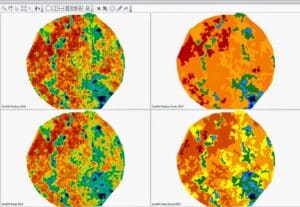
An EM Survey measures two soil profiles, one measuring the variability in the top 0-50 cm of soil and the other looking at variability in the top 0-125cm of your soil profile. Following a survey customers receive a comprehensive report outlining the findings in each survey depth. Depending on the variability arising from the survey, different management zones can be created to suit the final application. These zoned maps can then be used as the basis for variable rate irrigation (VRI) variable rate fertiliser, variable rate seeding and much more.
Figure 1. Top left is a shallow EM map and to the right of it a zoned map of that layer. Below is the same but for the deeper EM (0-125cm).
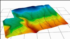
As well as collecting detailed soil information, and EM Survey also collected detailed topographic information. This data set in its own right is very useful and builds a deeper understanding of the role surface topographic changes play in water movement across the area. Coupled with the soil variability data itself this data can identify key areas for management changes to make a large difference to paddock, pasture, crop and nutrient management.
Figure 2. Specialist precision ag software generates water movement models based on the topography data.
Another simple but effective use for EM Survey data is to use it for placing soil moisture probes based on soil variability and slope to find your optimum site within each management zone. These sites can also be used as ground-truthing sites for water-holding capacity. From these your EM map can then be converted into a water-holding capacity map
EM Surveying information can be used for a myriad of uses, not all of which we’ve covered in this article. As soil is the basis for farming the land we work with, it makes sense to ‘dig a bit deeper’ and start our precision ag journey with a deeper understanding of our soils.
New to the Vantage portfolio is water-holding capacity assessments. These work alongide our EM Survey to aid in making more informed decisions. You can find out more about water-holding capacity assessments and what they add here.
To understand how EM Surveying can be used in your business, reach out to the Vantage NZ team to learn more.
From time to time we get the query: “my soil moisture sensor hasn’t responded to recent irrigation events, there must be something wrong with the sensor”.
While it is easy and natural to blame the sensor, the reason is often found in the field. There are physical reasons why a sensor may not register an event and the problem could be caused by a combination of these.
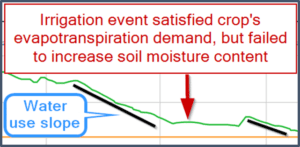
Figure 1. An irrigation event causing a neutral change in soil moisture content.
Canopy interception
The crop’s canopy will intercept some of the rainfall and/or irrigation water. Obviously, this will vary greatly from crop to crop and throughout the growth stages. It stands to reason that a mature crop of maize will intercept more water than freshly grazed pasture.
Much of the intercepted water will evaporate, but while it is sitting on the leaf it will cool the leaf and reduce the plant’s evapotranspiration rates.
Some of the intercepted water will trickle down the stem and enter the soil at the plant base, but not in sufficient quantities to register at the first sensor depth.
This scenario will look like a neutral response on the soil moisture graph (Figure 1). The irrigation event has not caused a soil moisture increase, but it did satisfy the plant’s evapotranspiration demand, so there is no water use for the day.
Application depth –less than daily water use and/or less than 0-100mm deficit
This tends to be a problem under pivots and fixed sprinklers. Daily irrigation of 4-5mm may not be enough to result in a significant change in soil moisture content at the first sensor depth (100mm). Firstly, some of the water will be intercepted. Secondly, the application may be less than the deficit present above the first sensor site, the water will infiltrate into the soil but may be absorbed in the top 50mm of soil. In this case the response to the irrigation event at the first sensor (100mm) will, at best be a “flattening” of the trace; soil moisture will remain at its current level.
Bypass-flow -dry soils and soil type
Bypass-flow occurs when water passes through the macro pores (or gaps between soil particles) and is not absorbed by the soil particles. Bypass-flow and soil type are linked; coarse texture soils have more macro pores, increasing the potential for bypass-flow.
Bypass-flow and soil moisture content are also linked. As a soil dries it can undergo slight structural changes which may result in increased macro-porosity. The effect of drying varies with soil type. A fine textured soil with higher clay content will tend to shrink; typically, at the surface of the soil resulting in opening of cracks in the soil. In coarser textured soils cracks will not develop, but individual aggregates will contract, increasing the soil’s macro-porosity.
Water passing through the macro pores, or cracks, may not be registered by the soil moisture sensor; firstly, because the slurry used when the sensor is installed will have fewer macro pores than the rest of the field; and secondly, because the water fails to ‘linger’ long enough to infiltrate and re-wet the dry slurry the sensor is installed in.
Lack of sensor response due to a dry soil profile is most common in crops where the readily available water is greatest, e.g. wheat or carrot seed.
It is less common in frequently irrigated crops where the readily available water is small, e.g. ryegrass pasture, vegetable seeds and peas.
Key management strategies
It is useful to think of the soil moisture sensor as any other tool on the farm; it needs to be maintained to work properly. The sensor responses will be more reliable if slurry is not allowed to dry out. Soil moisture sensor management strategies include:
Adjust application depth to overcome crop interception.
Adjust application depth to be greater than daily water use.
Adjust application depth to ensure irrigation water will replace the target deficit.
If the slurry has dried and sensor response is lost, this is resolved through long duration rainfall, rather than re-installation of sensors. Usually all sensors regain perfect contact with the soil over the winter months.
At Vantage NZ we are proud to supply you with high quality AquaCheck soil moisture sensors and neutron services and to back it up with a high standard of service and expertise. Give us a call to discuss your soil moisture monitoring requirements and get set up in good time for the 2021-22 season.
Article written by: Jane Robb, Customer Support Specialist
Vantage NZ is New Zealand’s leading precision agriculture expert providing growers all over New Zealand with precision agriculture products, services and expertise for the entire block.
At the root of it, precision agriculture and the technology behind it allows growers to easily record and collect detailed information across their block at a spatial level. GPS enabled tractors, spatial farm maps and soil maps, GPS-recorded soil nutrient test and much more all further enhance the understanding of why crops are performing like they are. Precision ag gives growers the confidence to tweak decision making at a spatial level to ensure all areas of the block are set up for maximum success.
Understanding your block from the ground up is integral to successful crop growth. EM (electro-magnetic) soil surveying has long been used as a precise method of understanding soil variability across a block and the effects it may have on crop growth and performance. How do I manage my light soil areas differently to my heavier soil areas? Are there pans across the block? These are all questions to be investigating particularly at the block planning phase, but equally in an established block. EM Surveying allows accurate identification of these differences so different decisions can be made in other areas of the block. For example, irrigation design might be matched to soil type variability or variety planting planned differently.
While understanding your soil is critical, so is soil moisture. Multi-depth capacitance-based soil moisture probes such as the AquaCheck allow detailed insight into soil moisture levels the whole way down the root zone, making irrigation management a breeze with accurate information, including soil temperature right at your fingertips.
With new nitrogen regulations coming into effect, it’s now even more important to ensure that inputs are recorded and fine-tuned as much as possible while ensuring optimised productivity and profitability within this regulated environment. Simplifying record-keeping through the use of integrated GPS displays and easy-to-use software apps such as Trimble Ag Software now take the hassle out of it all. Trimble Farmer Core and Farmer Pro offer solutions from basic record keeping through to full work-order planning and crop scouting.
Having identified all this variability and having these maps is all good and well, but you still need the hardware to control the application, and that’s where the Trimble display range can help. From the entry-level GFX-350 right up to the TMX-2050 there’s a solution for whatever your needs are be it basic guidance, section control, steering or much more. Trimble is currently offering a trade-up program for old displays whether they’re Trimble or not so if you’re interested in upgrading get in touch with the Vantage NZ team today to find out if you qualify.
Vantage NZ is your one-stop-shop for all your precision ag needs. To find out more about how precision ag could help your farming business call 0800 482 682, or contact us info@vantage-nz.com.
Precision agriculture can sound complicated and technical, but it is just an extension of everyday farming, says Jemma Mulvihill from Vantage New Zealand.
“Simply put, it’s about using the right tools and products for the right application to solve a problem. The results are better environmental management and farming efficiencies,” she says.
Since it started in 2010 Vantage New Zealand (formerly Agri Optics New Zealand Ltd) has grown to be New Zealand’s leading precision agriculture solutions provider. In February 2020 the company was re-branded and re-launched as Vantage NZ, combining the highly skilled and knowledgeable staff from both Agri Optics NZ and GPS Control Systems when the company purchased the Trimble dealership for New Zealand. Jemma says the result has been a more comprehensive suite of services, products and solutions covering the gamut of what farmers may require from one source.
“We are now New Zealand’s only full-time dedicated precision agriculture provider offering a full spectrum of products so we can assist farmers the whole way through the journey, making it more efficient and cost-effective for them to get the support they are after.”
With its head office in Methven and team based around the country Vantage NZ can provide precision agriculture service and support across New Zealand. Jemma says Vantage NZ has a great team offering many years experience, which is important to maximise the potential for clients and to support them all the way through.
She points to examples, such as electromagnetic soil surveying and soil moisture monitoring, as to how precision agriculture solutions can make a real difference to a farmer’s operation.
“By understanding the soil variability across a farm, this can inform irrigation and nutrient application decisions. For example, you might lower the amount of water placed on lighter soils or apply a little frequently, whereas, on heavier soils, you may be able to apply more. Savings in water usage and electricity can be a significant return on investment and also result in the farmer growing better crops. Similarly applying nutrients in the right amounts depending on the soil maximises potential without waste or negative environmental outcomes.”
Precision agriculture solutions can also help farmers to avoid some of the dreaded paperwork, she says. For example, the Trimble GFX-750 display can connect the entire operation with innovative, fully integrated software solutions that transform the way people farm by, for example, sending jobs to tractors from a cell phone or computer and generating farm proof of placement reports etc.
Jemma says because Vantage NZ was established off the back of on-farm use through its founders and directors, this gives a grassroots understanding of what farmers really need. “Our key focus is on helping as many farmers as we can to implement precision agriculture in a sustainable and goal-driven way in their businesses. For us, that starts with understanding the customer’s issues and bringing solutions to the market that make a real difference.”
Article published in: Business Rural South, September 2020